
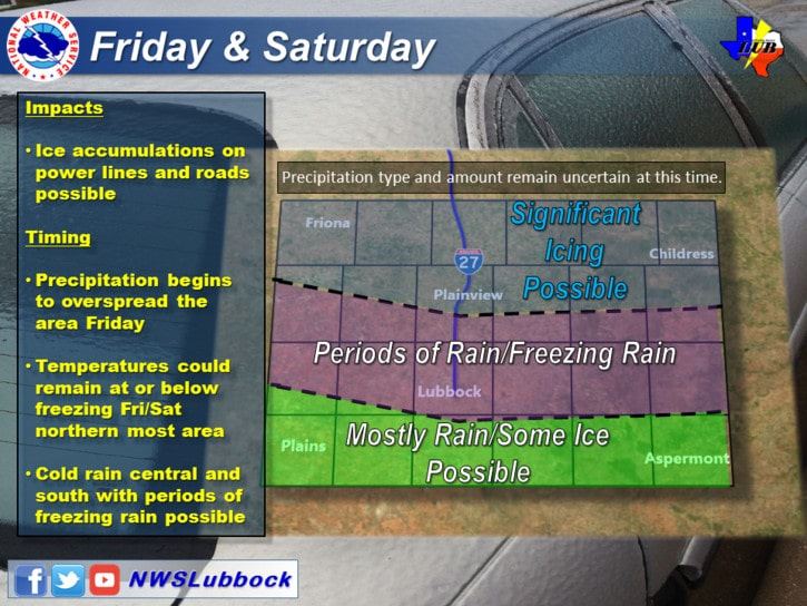
Winter weather potential for West Texas. Updated graphic for the Panhandle not available at the time of this posting. .
At this juncture there have been little in the way of forecast changes for our upcoming weekend system. The only trend seen in weather model guidance today is a continued warmer solution. This warmer solution increases confidence that any winter weather issues will be confined to the Texas Panhandle, perhaps only the northern Panhandle if the warmest solutions are correct. Overall this means a majority of the winter mischief will likely remain to our north in the Oklahoma Panhandle, northern Oklahoma, into Kansas. That’s good news since someone is likely to get one of those nasty ice storms that gets remembered for years to come. We’ll keep watching data as adjustments are still possible, and it is certainly not out of the realm of possibility that the freezing line tries to hang around a bit longer in the Panhandle, West Texas, and far Northwest Texas on Saturday and Sunday. Again, check back for forecast updates as we’re just making general assumptions at this point. As we get closer in time and the storm system gets sampled by the upper air network on the west coast we’ll be able to focus in on a particular forecast solution.
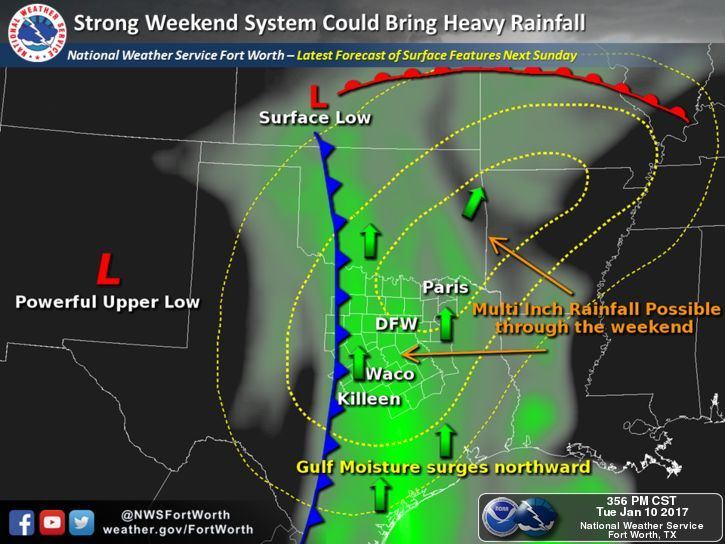
The main story this weekend into early next week will be widespread rain potential. Moisture values are expected to be 200 to 350 percent above normal for January. That means we could see some impressive rainfall amounts with efficient rainfall producers. Since we’re talking about a system several days off we won’t get specific on who could see the most rain. However, there may be a large swath of 2 to 4 inch rainfall accumulations along and east of Interstate 35 from Kansas south to Central Texas. Specific rain total forecasts will depend on where a cool front stalls out, as it will become a focal point for heavier rainfall. Some spots in proximity of that stalled front could see up to 6 inches of rain by Tuesday morning. Even though we are in drought conditions we also must consider that vegetation is dormant. That dormant vegetation won’t be able to take much water, thus increasing runoff. Get a couple inches of rain in a few hours and that means the potential for localized flash flooding. At this point we’re not expecting a major/widespread flood outbreak. The best rain chances will be Saturday throughout Monday.
The overall risk for severe storms continues to look low with this upcoming storm system. With model solutions trying to come in warmer we’ll have to watch for an increase in the potential for a few strong storms. That potential will be better defined in later forecasts as data becomes more clear/accurate.


0 Comments