
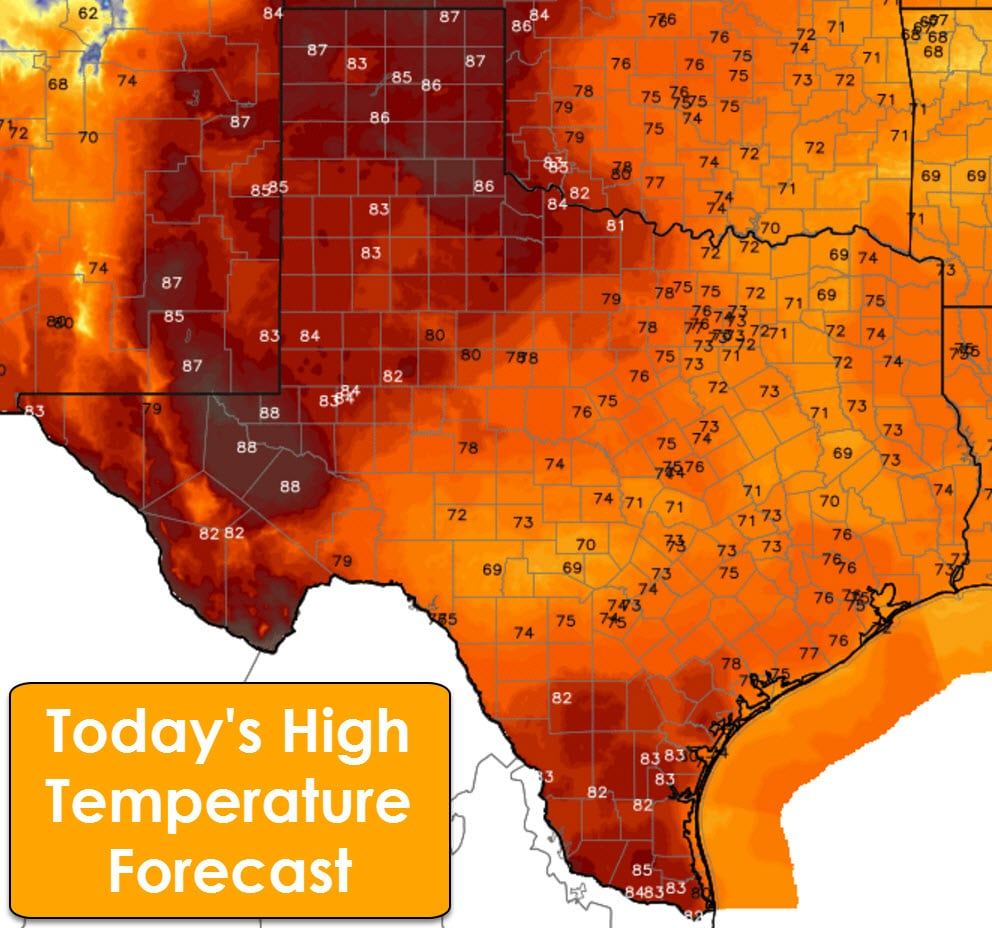
A pattern change will allow for more seasonal weather next week including the chance of precipitation. Until then, we’re going to be dealing with very warm temperatures and high fire danger. Record highs are forecast in the Texas Panhandle, West Texas, into the Permian Basin this afternoon with middle to upper 80s – a 90 degree reading is certainly possible. The eastern two-thirds of Texas will see 70s this afternoon with South Texas and the Rio Grande Valley in the lower to middle 80s.
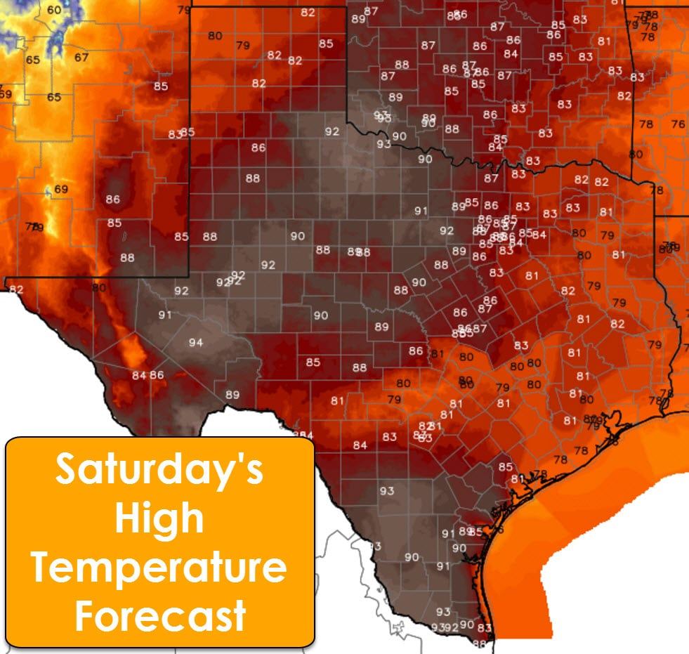
Saturday will be a very unusual February day across Texas with record high temperatures in the forecast. Northwest Texas, the Big Country, western North Texas, the Permian Basin, and South Texas are all forecast to reach the 90s on Saturday. It is not out of the question that we see a few middle to upper 90s across the Permian Basin into Northwest Texas. Not only are we going to see several new record highs tomorrow afternoon, but some spots may actually approach their all-time record high for the month of February. The Texas Panhandle, Borderland, Central Texas, Northeast Texas, East Texas, and Southeast Texas will range from the upper 70s to the middle 80s. Low relative humidity values and dormant fuels will promote very high to critical fire danger – especially where we see upper 80s and 90s. Saturday will feel more like a June day versus February.
Changes arrive on Sunday as we start to see precipitation chances ramp up. Most rain chances on Sunday will be sprinkles or very light precipitation. The forecast for the upcoming week will depend on the track of the storm system and the timing of it as well. Compared to yesterday’s forecast we have seen the timing slow down a bit. That’s why more of Sunday should be dry or at least only feature light rain/sprinkles. It’ll still be cloudy though. We’ll see precipitation chances ramp up on Sunday Night and into Monday from west to east. Numerous showers and a few storms are possible on Monday through Tuesday Night. At this time the threat of severe weather looks low. Some winter precipitation may occur in parts of the Texas Panhandle and far West Texas on Sunday and Monday nights. We’ll deal with any potential accumulation issues on Saturday as the data becomes more clear.
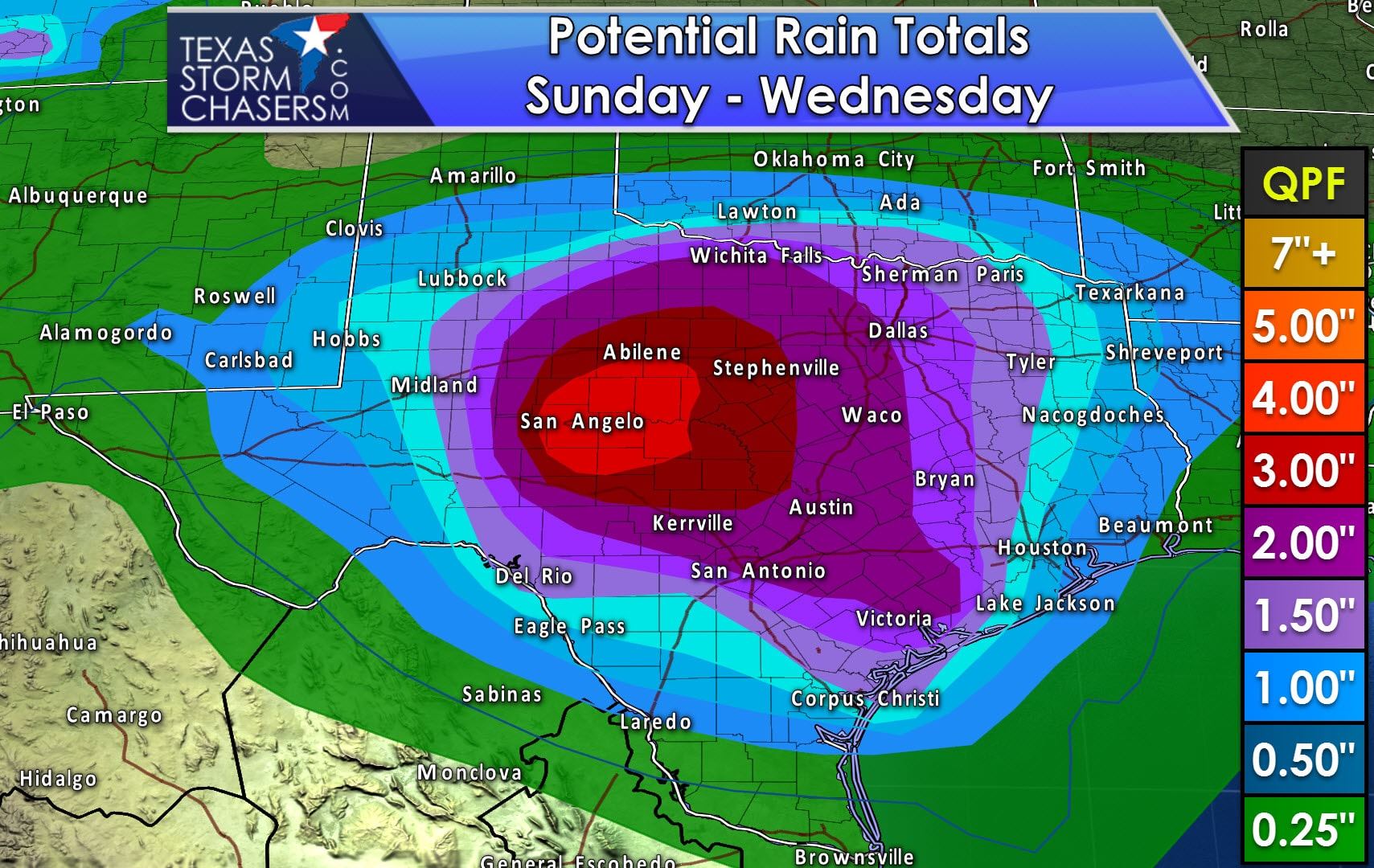
The best chances for accumulating rainfall will be on Monday and Tuesday. At this time it looks like a good soaking is in store across the Concho Valley, Big Country, Hill Country, Central Texas, North Texas, East Texas, Northeast Texas, Southeast Texas, into the Brazos Valley, and Middle Coast. Honestly, I think most folks will see at least some rain by the time we get to Wednesday. Widespread rain totals of 1 to 2 inches are possible where the blue and purples are highlighted on the graphic. Localized rain totals up to 3 inches may occur, but we’ll nail down the more specific rain total forecasts once we get into Saturday. Widespread flooding looks unlikely as of now, but we’ll keep an eye on the threat for some localized flooding if rain totals go up early next week.
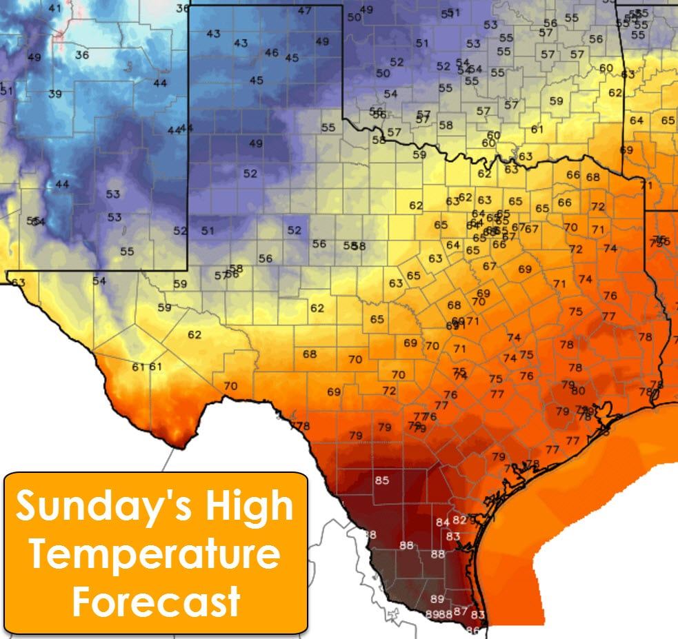
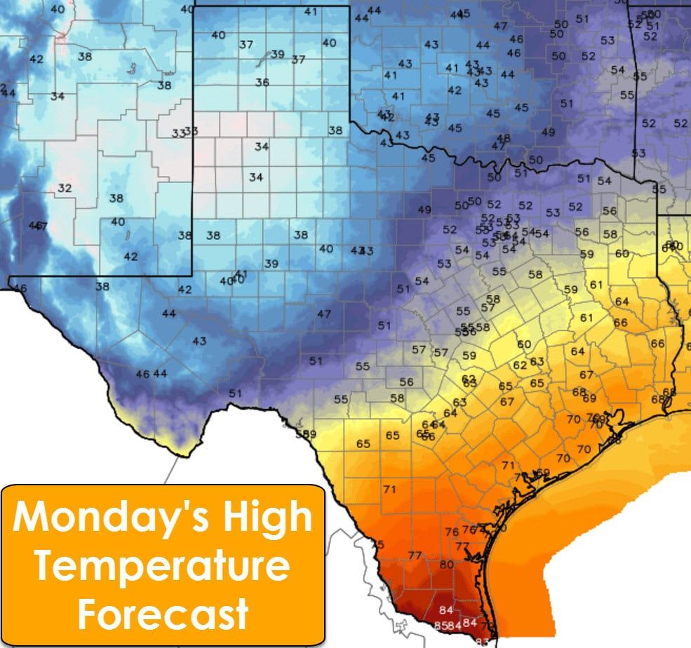
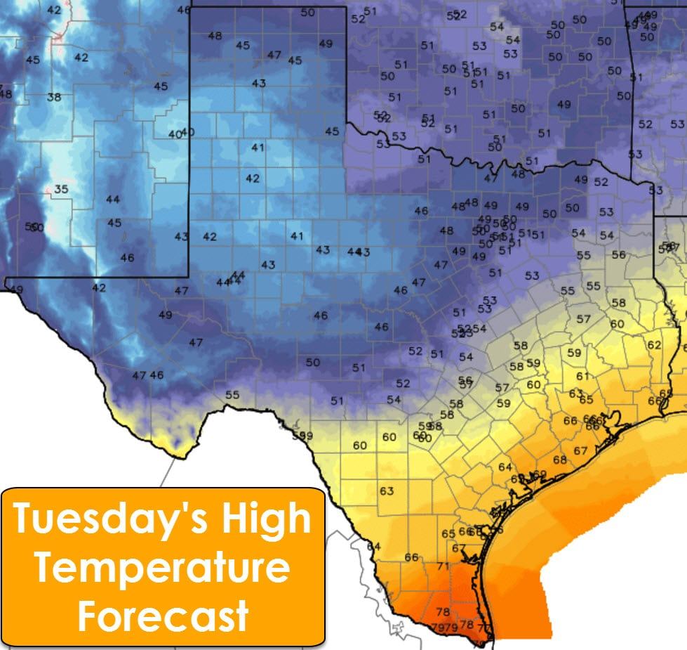
With the increased rain chances early next week also comes a strong cold front. This front will make slow progress from north to south beginning Saturday Night and continuing through Monday. This front will bring temperatures back down to seasonal averages north of it with 30s, 40s, and 50s as the daytime high. The front will eventually stall out somewhere in the Southwest Texas-Central Texas-Northeast Texas area on Monday. South of the front we’ll see temperatures remain in the 60s and 70s during the day – with fog possible at night. It’ll be dramatically cooler north of the front by Sunday compared to the next two days.


0 Comments