

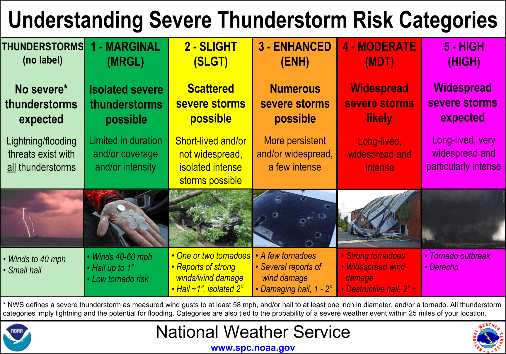
The Storm Prediction Center maintains a category 1 severe weather risk for this afternoon through the pre-dawn hours Tuesday. This risk includes Southwest Texas, the Concho Valley, the Hill Country, and portions of Central and South-Central Texas. We’re not expecting too many severe storms tonight as the ingredients to support severe weather don’t ramp up until Tuesday morning in Southeast Texas. Nevertheless, dynamic wind fields and a bit of instability in the mid-levels of the atmosphere may allow a few storms to produce nickel to quarter size hail and very localized wind gusts of 55 to 60 MPH. The threat of a brief tornado is very low, and it would be more of a surprise than not if we had one west of I-35 tonight. That said, its always a good idea to have a way to receive severe weather warnings.
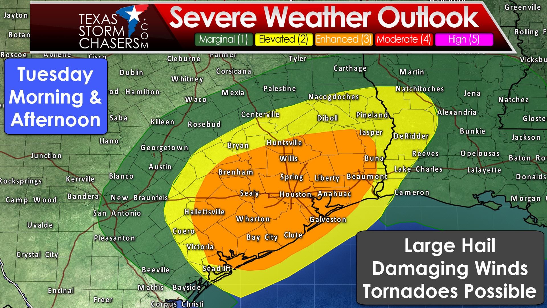
We now have a category 3 risk of severe weather for Southeast Texas for the morning and afternoon hours Tuesday. All modes of severe weather will be possible, including the possibility of a couple of tornadoes. Hallettsville, Bay City, Brenham, Houston, Huntsville, Liberty, and Beaumont are cities included in the category 3 risk. A category 2 risk surrounds the category 3 and includes Cuero, Bryan/College Station, Nacogdoches, and Pineland. The threat for severe weather will be highest in Southeast Texas as a warm front moves north and surface-based instability is able to advect inland. The probability of severe storms decreases with northward extent in East Texas, but some some of the storms may produce strong winds. Severe thunderstorms may begin as soon as 7-8 AM in the risk zones and should be ending in far East Texas and Southeast Texas by 4 PM. Hence, we’ll be dealing with a morning-type of event, just like back in January.
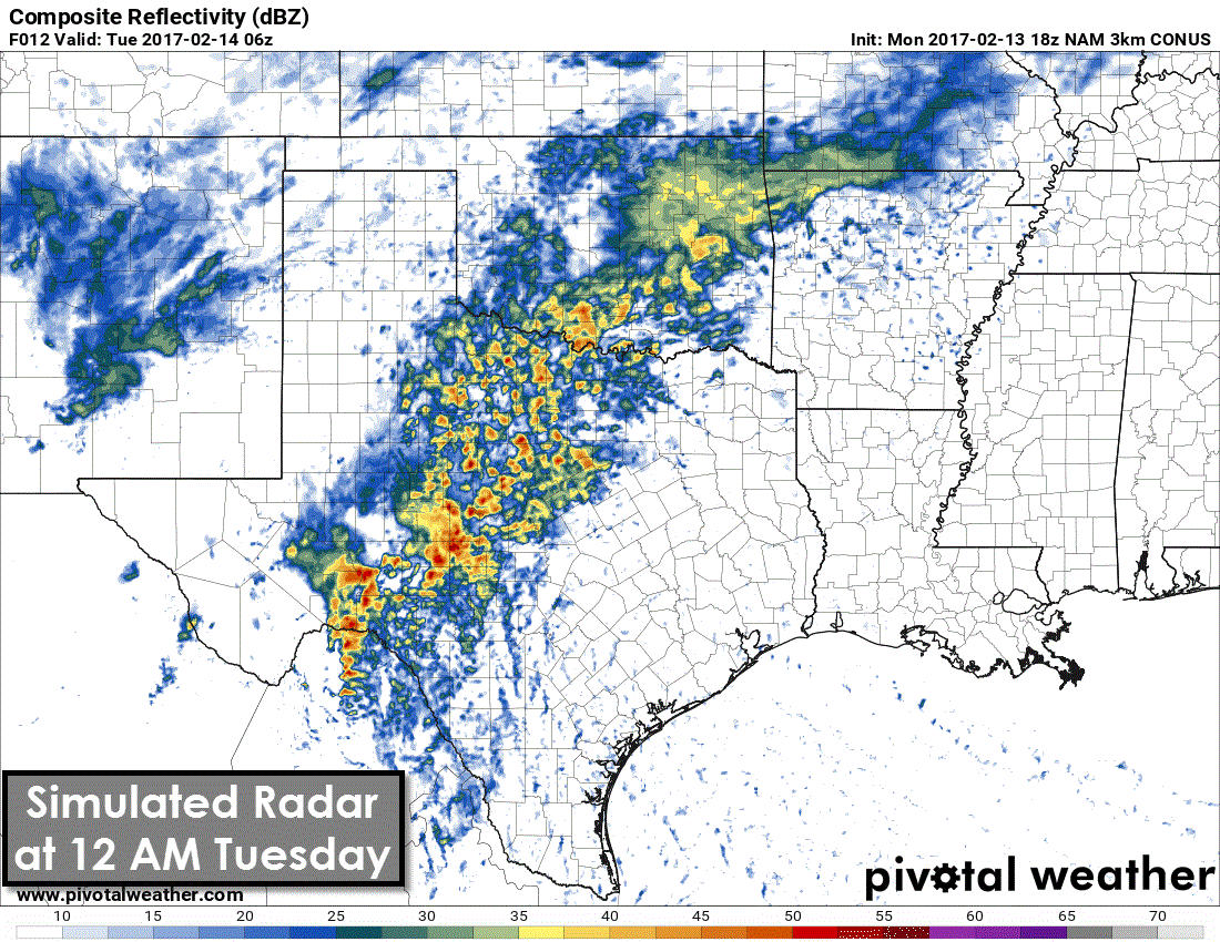
Tonight/Early Tuesday: Widespread showers and thunderstorms should be underway by late evening across the western half of Texas. Temperatures may support a changeover to snow in parts of the Texas Panhandle and northern sections of the South Plains where a winter weather advisory is in effect. We’re not expecting too much in the way of accumulations thanks to the recent warm weather, but we’ll keep an eye on things since winter in Texas always has a few surprises. It’ll be all rain elsewhere with storms increasing in coverage across North Texas, the Big Country, Concho Valley, and Southwest Texas. A line of storms will likely start to organize by 3 AM tonight in eastern sections of the Concho Valley into western Central Texas and the Hill Country. I can’t rule out some storms in this line producing gusty winds. However, it looks like we should be able to hold off most of the severe weather potential until the line gets near Interstate 35 in Central and South Texas. This is where we’ll see an uptick in instability values as a warm front lifts northward. Some storms in the squall line will likely produce damaging straight-line winds, small hail, and very heavy rainfall.
Tuesday Morning/Tuesday Afternoon: Storms will continue to move east Tuesday morning into the Brazos Valley and Southeast Texas. If the storms remain linear, as a squall line, the primary threat from the strongest storms should be strong straight-line winds of 45 to 70 MPH. Brief tornadoes can’t be ruled out in particularly intense segments of the squall line. Heavy rainfall will be likely which may cause minor flooding. If we have any discrete storms develop just ahead of the squall line then we’re going to see those try and rotate. It is with any discrete storm that we’ll be most concerned about the possibility of tornadoes. This threat is highest in Southeast Texas during the morning and early afternoon hours tomorrow. Most high-resolution weather model guidance is consistent in showing the squall line moving east of Texas by 3-4 PM CT.
In summary: Most storms tonight will remain well below severe limits. The threat for severe storms increases after 6-7 AM in the Brazos Valley and eastern sections of Central and South Texas. The severe weather threat will move into Southeast Texas by mid-morning where the highest threat zone will reside. Once the squall line moves past a given location the severe weather threat will be over. Damaging straight-line winds look to be the most likely hazard, but hail and a couple of tornadoes are possible. Any discrete storm that develops ahead of the squall line could have an enhanced tornado threat. We may not get any organized discrete storms at all tomorrow, but it all depends on mesoscale (localized) factors we simply can’t anticipate more than a few hours out.


0 Comments