
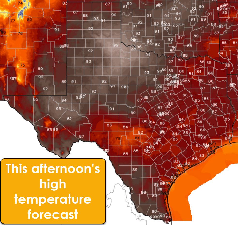
Welcome to the first day of Spring in the Northern Hemisphere! Our friends down under are headed into fall, which will hopefully bring a quick end to their fire season. No such luck for us as elevated to critical fire weather danger expands by the end of the work week. This afternoon’s high temperature forecast isn’t too bad if we were in July, but its downright hot for mid-March. Lets start off by saying a big congratulations to Childress. They’re forecast to top out at 99 degrees this afternoon – the warmest in the United States. Sadly, I’m fairly confident we’re going to see at least a couple 100 degree readings pop up in Northwest Texas and the southeastern Texas Panhandle this afternoon. Middle 90s are expected across the southern Panhandle, Western North Texas, the Big Country, into the Permian Basin. It will not feel like March this afternoon, it’ll feel more like July. Since it felt like April in January I suppose it is only fitting.
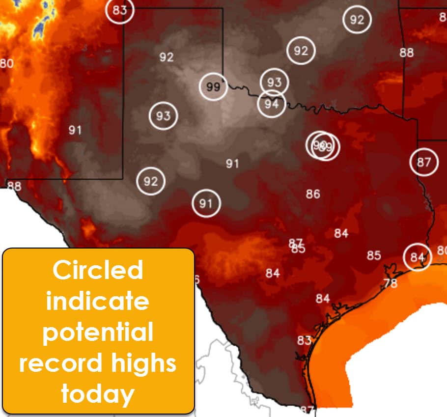
Conditions across the eastern and southern half of Texas will be quite warm, but not to the extremes further west. Increased moisture values can be thanked, in part, to temperatures not approaching the middle 90s this afternoon. We’ll still see well above-average temperatures peak in the middle to upper 80s. South Texas will approach 90 degrees. Several high temperature records are in jeopardy across the Permian Basin, West Texas, Concho Valley, Northwest Texas, into North Texas.
A potent upper level storm system and associated surface low will bring a change to our weather by Thursday, Friday, and Saturday. A line of thunderstorms may initiate as far west as the Texas/New Mexico border from Dalhart all the way south into the Permian Basin during the evening hours Thursday. This linear convection would be associated with a dryline/cold front combination. It would move east during the night-time hours Thursday into the morning hours Friday into Northwest Texas, the Big Country, Concho Valley, and Hill Country. Eastward progression would continue into Friday with the highest rain chances in North Texas, Northeast Texas, Central Texas, the Brazos Valley, East Texas, and Southeast Texas. At this time, the chance of South Texas and the Rio Grande Valley being impacted looks to be on the lower-end of the spectrum.
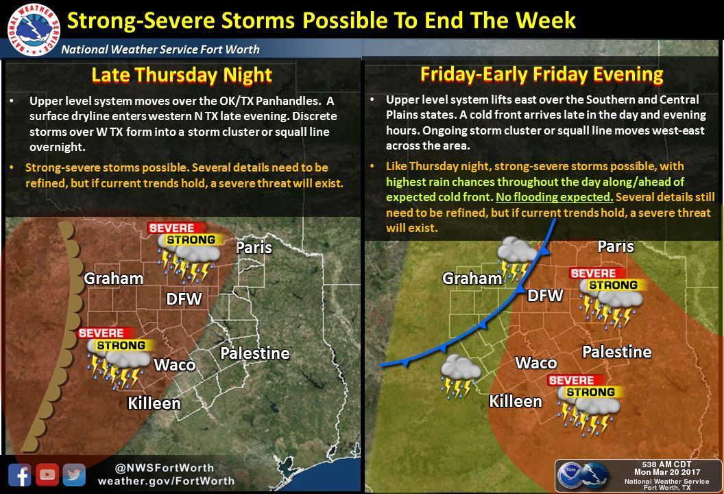
Should present indicators hold there will be a risk of severe weather on Thursday and Friday. Not all storms will be severe, nor will everyone experience high-impact weather. This graphic from the National Weather Service in Fort Worth shows the generic setup. Understand that this graphic is for North Texas, and does not specifically indicate the threat for other sections of Texas. Should we be dealing with a linear, squall line the primary threat could be localized damaging straight-line winds. We’ll refine the specific risks and locations over the coming days. I’m sure Jenny will have more details in her evening blog later on.


0 Comments