https://youtu.be/in89kq7bffI?si=onXbJ5fitTj0HUR_ The chance of severe thunderstorms – capable of producing damaging...


https://youtu.be/in89kq7bffI?si=onXbJ5fitTj0HUR_ The chance of severe thunderstorms – capable of producing damaging...

Many have asked, and we're happy to share that we have finally created a graphic with a Texas regional map and...

https://youtu.be/zy9FD0hSq28 Daily chances for rowdy thunderstorms and windy conditions will be two weather concerns...

https://youtu.be/g0SO_5TdB8M Unsettled weather will bring a return of thunderstorm chances to parts of Texas over the...

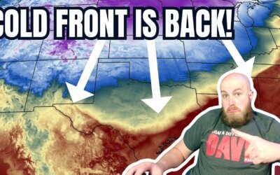
https://youtu.be/tZd6BxRdH_o A strong cold front will bring a little chill back to Texas this weekend with widespread...

https://youtu.be/f0Z3y4lc-_0 Active weather returns to Texas for the remainder of the week. Today's scattered severe...

https://www.youtube.com/watch?v=czAhPxWGG0Q A few showers and storms with small hail are possible in the Ark-La-Tex...

A total solar eclipse followed by a two-day severe weather outbreak has made for a busy week across Texas. We have one...

Thunderstorms will be the name of the game in Texas today, with continued chances of large hail and flooding rains in...
April 8, 2024 #LIVE #Texas #Tornado coverage from Baldy-in-Chief David...
April 8, 2024 #LIVE #Texas #Tornado coverage from Baldy-in-Chief David...

https://youtu.be/6sFEDoc8qbs The eclipse is hours away and clouds are moving north from the Gulf of Mexico. An...
Good evening! Here is a 9:30 pm update on tomorrow’s cloud cover potential...

https://youtu.be/inRPdmYrUk4 Texas is one day away from experiencing a generational event – a total solar eclipse....
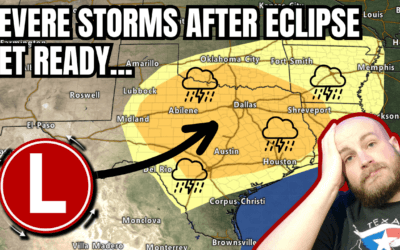
A multi-faceted, multi-day severe thunderstorm and flooding event will follow an eclipse in Texas next week. The...
Warm and windy weather will close out March across Texas. Easter Weekend...
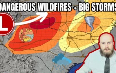
https://www.youtube.com/watch?v=rof7FfXZFag Today, we are facing a critical and dangerous situation as dangerous...
Yesterday will go down as a red-letter day in the history books of the Texas Panhandle with multiple, fast-moving...

https://www.youtube.com/watch?v=O8oXrL7CxVE After two days of warmth, crashy the cold front has brought the arctic...
Baldy-in-Chief David Reimer has a Sunday evening update on how long...