https://youtu.be/in89kq7bffI?si=onXbJ5fitTj0HUR_ The chance of severe thunderstorms – capable of producing damaging...


https://youtu.be/in89kq7bffI?si=onXbJ5fitTj0HUR_ The chance of severe thunderstorms – capable of producing damaging...

Many have asked, and we're happy to share that we have finally created a graphic with a Texas regional map and...

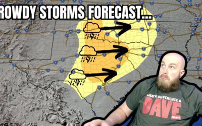
https://youtu.be/zy9FD0hSq28 Daily chances for rowdy thunderstorms and windy conditions will be two weather concerns...

https://youtu.be/g0SO_5TdB8M Unsettled weather will bring a return of thunderstorm chances to parts of Texas over the...

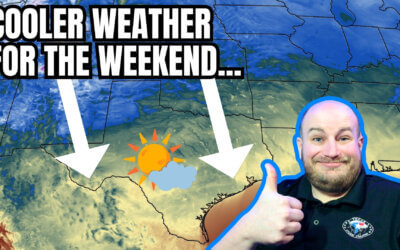
https://youtu.be/tZd6BxRdH_o A strong cold front will bring a little chill back to Texas this weekend with widespread...

https://youtu.be/f0Z3y4lc-_0 Active weather returns to Texas for the remainder of the week. Today's scattered severe...

https://www.youtube.com/watch?v=czAhPxWGG0Q A few showers and storms with small hail are possible in the Ark-La-Tex...

A total solar eclipse followed by a two-day severe weather outbreak has made for a busy week across Texas. We have one...
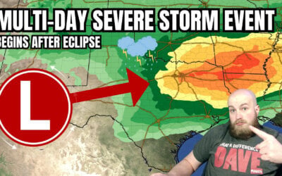
A multi-day severe storm event will follow an eclipse in Texas next week. Somehow, I figured Mother Nature wouldn’t...
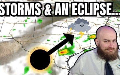
An eclipse for lunch and severe storms by dinner? Welcome to Texas weather in April. That appears to be on the agenda...
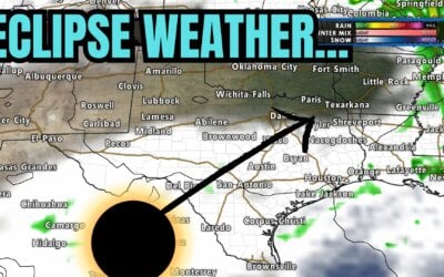
https://www.youtube.com/watch?v=MZYJZSo2TS0 All eyes are on the eclipse Texas weather forecast for Monday. We'll cover...
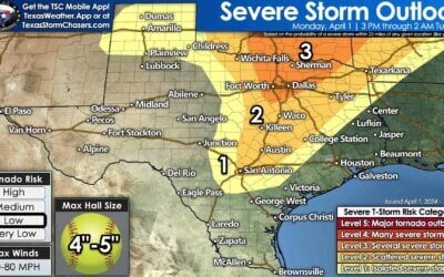
https://youtu.be/4F1q4r6gfh0 Parts of Texas will start April off with a literal bang—with the possibility of severe...
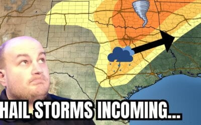
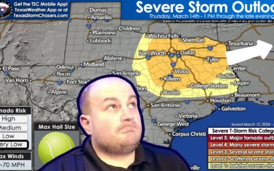
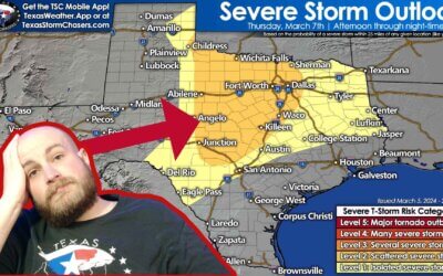
The potential for several intense supercell storms this afternoon and evening has increased in Texoma and North Texas...
https://www.youtube.com/watch?v=ADjVRCxJiPw The final days of March will be dry across Texas. Precipitation chances...
https://www.youtube.com/watch?v=j3zb6Mnekbo An isolated severe thunderstorm, potentially dangerous, is possible as...
https://www.youtube.com/watch?v=uIPdPGlscOs The weather across Texas is about to play switcheroo regarding...
Storms and snow are forecast for Texas today. While it's unlikely for the two to coincide in the same location, we...
https://www.youtube.com/watch?v=g7-0kC-n6nY Tuesday afternoon brought isolated thunderstorms to portions of Texas....
https://www.youtube.com/watch?v=tTbJNiXQO44 Thunderstorms are making a ruckus across the Ark-La-Tex and East Texas...
Well, yesterday sure was something. From fourteen inches of snow in Plainview on Interstate 27 to reported tornadoes...