https://www.youtube.com/watch?v=czAhPxWGG0Q A few showers and storms with small hail are possible in the Ark-La-Tex...


https://www.youtube.com/watch?v=czAhPxWGG0Q A few showers and storms with small hail are possible in the Ark-La-Tex...

A total solar eclipse followed by a two-day severe weather outbreak has made for a busy week across Texas. We have one...
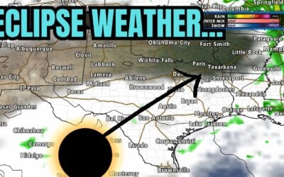
https://www.youtube.com/watch?v=MZYJZSo2TS0 All eyes are on the eclipse Texas weather forecast for Monday. We'll cover...
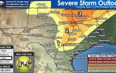
The potential for several intense supercell storms this afternoon and evening has increased in Texoma and North Texas...

https://youtu.be/NUYFE0yAXrs The final day of March has arrived, and so has Easter. May you enjoy the day the Lord has...
This afternoon, we've had multiple reports of brief tornadoes in the...
The remainder of Saturday will feature pleasant weather across Texas. The...
https://www.youtube.com/watch?v=j3zb6Mnekbo An isolated severe thunderstorm, potentially dangerous, is possible as...
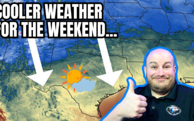
https://www.youtube.com/watch?v=uIPdPGlscOs The weather across Texas is about to play switcheroo regarding...
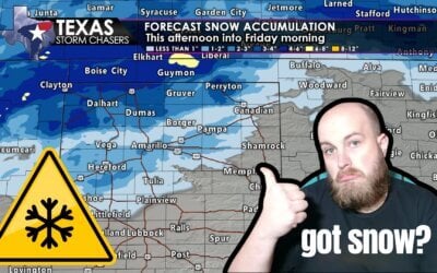
Storms and snow are forecast for Texas today. While it's unlikely for the two to coincide in the same location, we...
https://www.youtube.com/watch?v=g7-0kC-n6nY Tuesday afternoon brought isolated thunderstorms to portions of Texas....
https://youtu.be/a9V9hAytA9U?si=hMGGJ3wMe9g7SPv8 This week, a warmer and wet weather pattern is setting up for a...
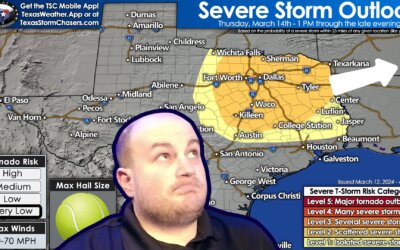
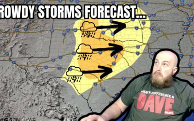
It's a special Sunday evening edition of the Texas Weather Roundup, with an active Monday expected across Texas....
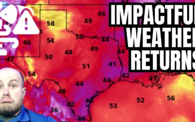
Dense fog this morning will slowly decrease in overall intensity through this afternoon. Sadly, some folks will remain...
Around 900-905PM a meteorite was observed by many across Oklahoma and at least the northern half of Texas. Some folks...
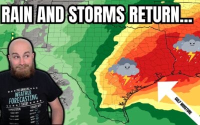
Widespread hit or miss rain chances will continue into at least Wednesday of the work week ahead. This in turn will...
Congratulations on making it to the end of another work week! We are starting the morning with a relatively widespread...
The summer of 2021 is not shaping up to be a drought-inducing, record-nasty heat for Texas. That kind of summer is one...
Very heavy rain has continued to produce flooding overnight in South Texas and the Rio Grande Valley. After several...
Happy Independence Day, Y'all! Remember, the reason for the season may apply more for Christmas, but it sure applies...