Many have asked, and we're happy to share that we have finally created a graphic with a Texas regional map and...


Many have asked, and we're happy to share that we have finally created a graphic with a Texas regional map and...

https://youtu.be/zy9FD0hSq28 Daily chances for rowdy thunderstorms and windy conditions will be two weather concerns...

https://youtu.be/g0SO_5TdB8M Unsettled weather will bring a return of thunderstorm chances to parts of Texas over the...
The weekend rain is gone, but Texas is starting off on the chilly side of the thermometer this late April morning....
Happy weekend Texas! David is out of town but Jason will give a weather...

https://youtu.be/tZd6BxRdH_o A strong cold front will bring a little chill back to Texas this weekend with widespread...

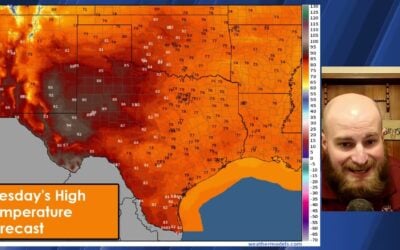
https://youtu.be/f0Z3y4lc-_0 Active weather returns to Texas for the remainder of the week. Today's scattered severe...
Texas’s hot weather will end this weekend as a cold front brings...

https://www.youtube.com/watch?v=czAhPxWGG0Q A few showers and storms with small hail are possible in the Ark-La-Tex...
Monday’s are already challenging, and now we have the added complexity of...
Latest severe weather outlook and forecast discussion for Texas Monday &...
All hands on deck April 15th with multiple live stream cameras across...

A total solar eclipse followed by a two-day severe weather outbreak has made for a busy week across Texas. We have one...
April 9, 2024 #LIVE #Texas #Tornado coverage from Baldy-in-Chief David...

Thunderstorms will be the name of the game in Texas today, with continued chances of large hail and flooding rains in...
April 8, 2024 #LIVE #Texas #Tornado coverage from Baldy-in-Chief David...
April 8, 2024 #LIVE #Texas #Tornado coverage from Baldy-in-Chief David...

https://youtu.be/6sFEDoc8qbs The eclipse is hours away and clouds are moving north from the Gulf of Mexico. An...
Good evening! Here is a 9:30 pm update on tomorrow’s cloud cover potential...

https://youtu.be/inRPdmYrUk4 Texas is one day away from experiencing a generational event – a total solar eclipse....