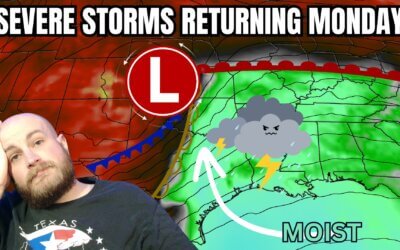
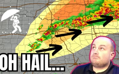
The potential for several intense supercell storms this afternoon and evening has increased in Texoma and North Texas...
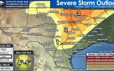

The potential for several intense supercell storms this afternoon and evening has increased in Texoma and North Texas...

https://youtu.be/NUYFE0yAXrs The final day of March has arrived, and so has Easter. May you enjoy the day the Lord has...
Warm and windy weather will close out March across Texas. Easter Weekend...
https://www.youtube.com/watch?v=ADjVRCxJiPw The final days of March will be dry across Texas. Precipitation chances...
https://youtu.be/Vh2z1fPNa38 Isolated to scattered thunderstorms are possible this afternoon and evening across the...
https://www.youtube.com/watch?v=Cm2fyVjlqqM A cool front has made its way across the northern half of Texas this...

https://youtu.be/Z8BA50OrHg8 The past 24 hours have been marked by intense storm activity across various parts of...
A line of thunderstorms is developing along a southeastward moving cool...
This afternoon, we've had multiple reports of brief tornadoes in the...
The remainder of Saturday will feature pleasant weather across Texas. The...
Scattered showers and a few rumbles of thunder continue across Northeast...
Scattered showers and thunderstorms are moving east across, well - the...
Rather dreary weather with showers and storms will be the name of the game...
Cloud cover will increase across Texas through the day as our next...
Tuesday will feature mostly calm weather across Texas. Clouds will hold...
Spotty showers will continue moving across the southern third of Texas...
Rain and behaving thunderstorms will continue to move northeast across the...
Multiple opportunities for rain will present themselves across Texas...
4 PM Thursday, March 16th Texas Weather Update | So far, we've been mostly...
https://www.youtube.com/watch?v=j3zb6Mnekbo An isolated severe thunderstorm, potentially dangerous, is possible as...