
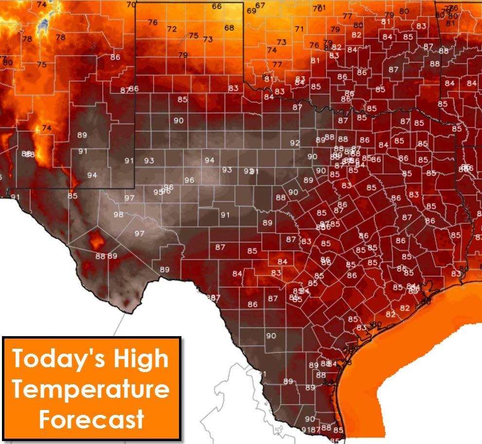
Record high temperatures are expected this afternoon in the Permian Basin where temperatures will peak in the upper 90s. Further north in the Panhandle temperatures will be about 20 degrees cooler than Monday. Middle to upper 80s are forecast for North Texas, Northeast Texas, East Texas, Southeast Texas, back west into Central Texas and the Hill Country. Lower 90s are a good bet in South Texas. These temperatures are above-average for late March, but that should come as no surprise considering it’s been going on for weeks. Isolated thunderstorms may develop in the Concho Valley, Big Country, and western North Texas this afternoon where temperatures get into the 90s. Should convective initiation occur some of the storms may produce locally gusty winds along with cloud to ground lightning. They would dissipate a few hours after sunset.
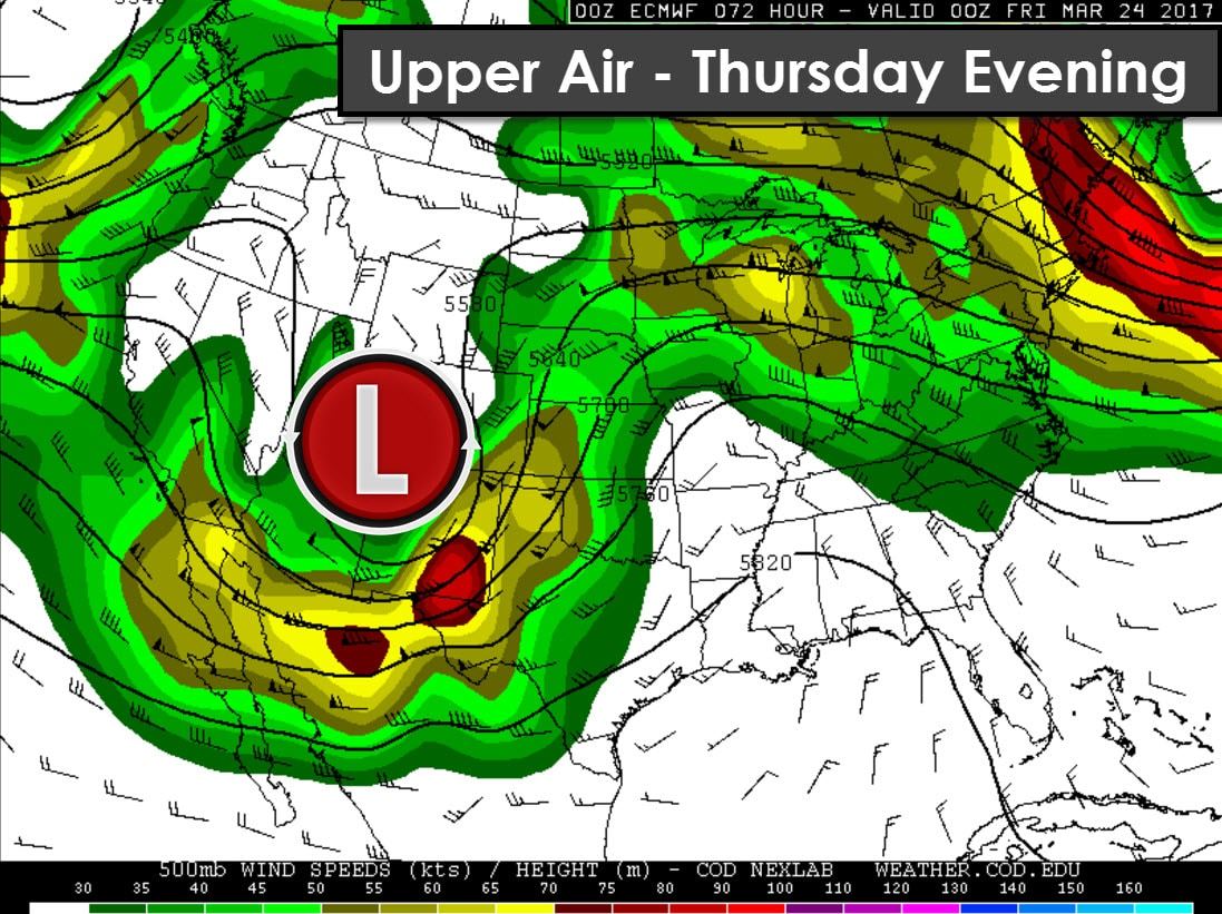
Our primary forecast concern will revolve around thunderstorm chances on Thursday and Friday. A negative tilt trough is projected to be over New Mexico by the afternoon hours on Thursday. A strong upper level jet will overspread the Texas Panhandle and West Texas during the day Thursday. At the surface we’ll see strong southeasterly winds with increasing moisture values. The dryline’s placement will likely be across western sections of the Texas Panhandle and West Texas – possibly as far west as the Texas/New Mexico line. Conditions west of the dryline will be very dry with critical fire weather danger. Dewpoints in the 50s just east of the dryline will help make the atmosphere unstable. Questions do remain on how much moisture will be available by the afternoon hours Thursday near the dryline. Too little moisture and the threat of organized thunderstorms may hold off until later in the evening when the dryline starts moving east, into a more moisture-rich enviornment.
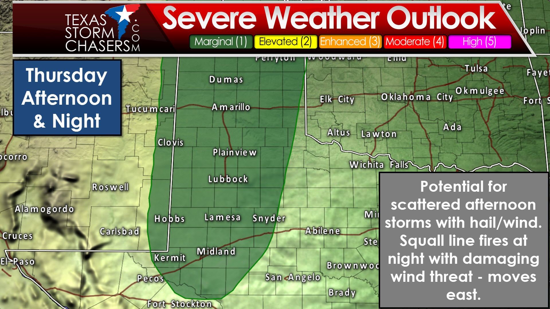
The Storm Prediction Center has placed a category one (marginal) risk of severe weather across much of the Texas Panhandle, West Texas, and Permian Basin. Dalhart, Dumas, Amarillo, Plainview, Lubbock, Lamesa, Andrews, Kermit, and Midland are in the risk zone. A marginal risk of severe weather means isolated severe thunderstorms are possible. The primary threats look to be large hail with any initial storms, before we see the damaging wind threat increase as a squall line develops Thursday evening. Again, several caveats exsist that could either decrease or increase the severe weather threat. If more moisture is available there is the possibility of supercells by late Thursday afternoon in the Texas Panhandle and West Texas. Those supercells would be capable of large hail and a low risk of a tornado. A line of storms will likely be underway by Thursday night – and that line will move east with a risk of localized damaging wind gusts. These regions definitely need rainfall, so they’ll take what they can get. Don’t expect a drought-breaker though.
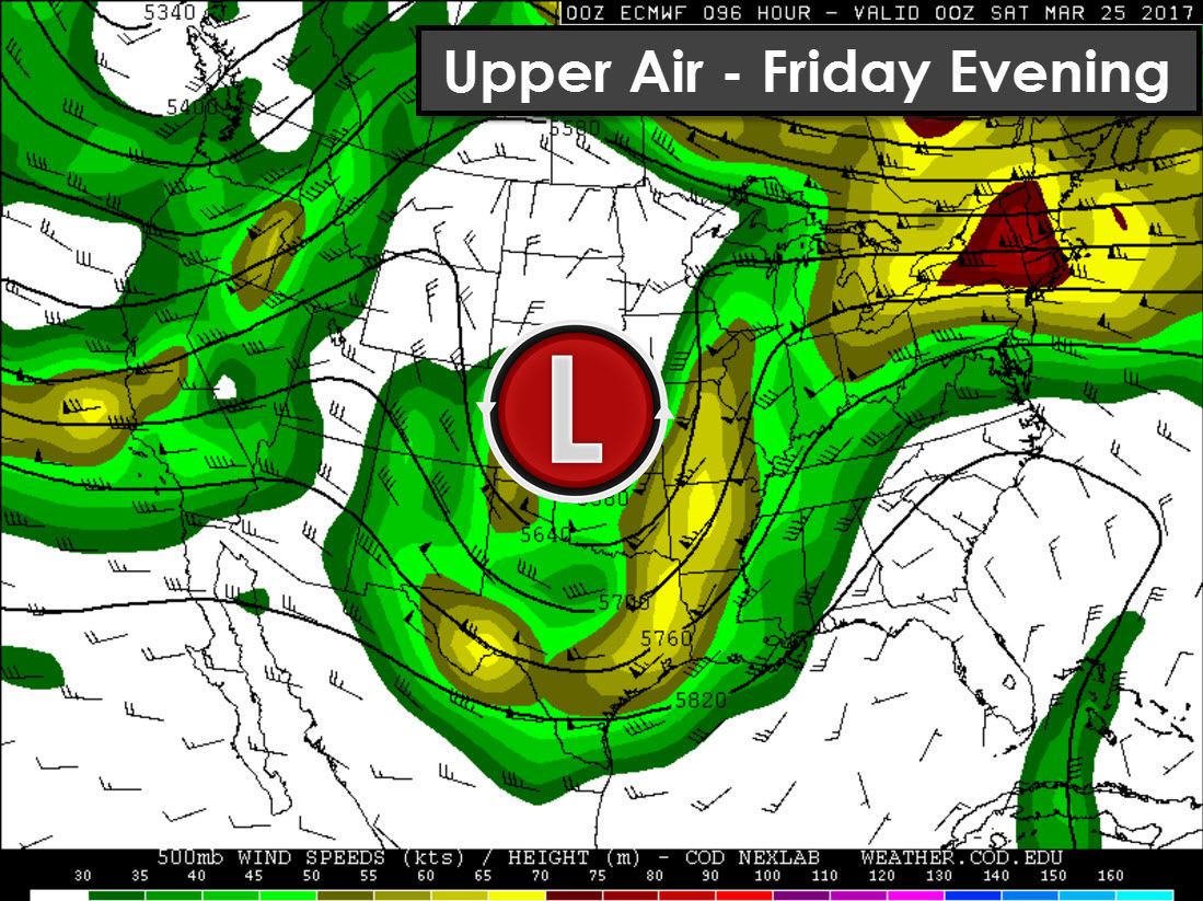
Our negative tilt trough could close off into an upper level low during the day Friday as it moves east. Timing aspects remain uncertain, and could either slow down or speed up by 6-12 hours in future forecasts. The capping ahead of the dryline/cold front on Friday morning will be negligible. In this scenario the threat of severe weather is actually less certain. Strong ascent from the nearby upper level low combined with little/no cap means widespread showers and thunderstorms are possible in the warm-sector. Please see the rain chance graphics below for where the ‘warm sector’ will be. Some strong storms are possible Friday morning across North Texas, Central Texas, into Northeast Texas, and East Texas as showers and thunderstorms move east.
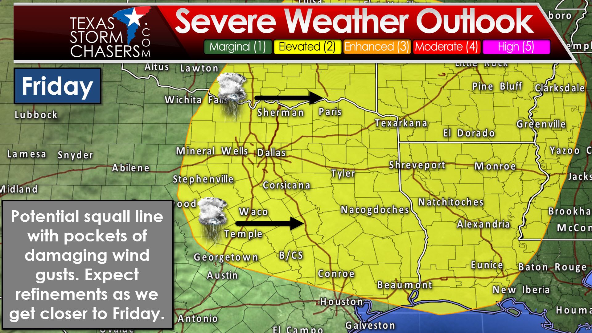
If we see widespread rain/storms occur before storms can become organized, the threat for severe weather will remain limited. Regardless, some gusty winds will be a possibility with strong wind fields in place. A conditional storm risk may develop Friday afternoon near Interstate 35 (or wherever the dryline stalls out). The risk for afternoon redevelopment will depend on how fast morning precipitation clears out, and if the atmosphere is able to destabilize. Should new storms develop Friday afternoon they would be capable of producing large hail and damaging wind gusts. These new storms would move east. A fairly linear wind profile means the risk of tornadoes should be very low with this setup. Being four days out we still have several unanswered questions, so some of the forecast’s aspects will change in future updates.
Rain chances should end from I-35 into eastern sections of Texas during the evening hours Friday as the storm system – and convection – move to our east. Should models continue to trend slower with this upcoming system, the timing aspects will likewise need to be slowed down.
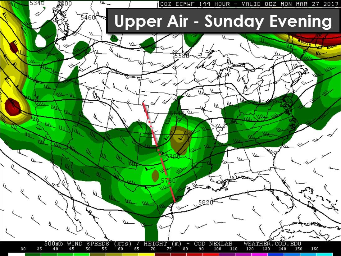
The end of March and much of April looks active as the ‘storm train’ continues to bring new upper level storm systems every 3 to 4 days. Both the American and European weather models show a second storm system moving into the Southern Plains on Sunday. We need to get through the Thursday/Friday system before focusing too much on Sunday, but severe thunderstorms may be a threat in portions of Northwest Texas, the Big Country, and North Texas. Additional storm systems will bring more chances of organized thunderstorms to Texas next week.


0 Comments