
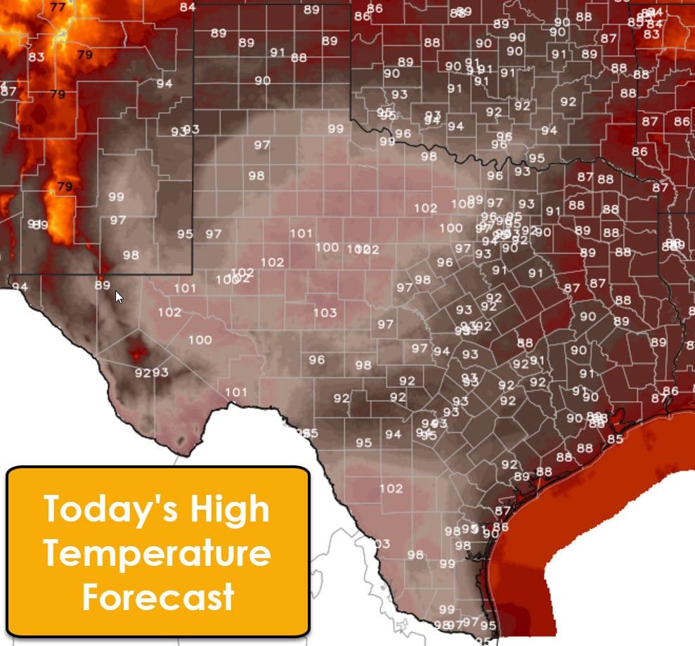
The primary weather story today and tomorrow will be oppressive humidity and the hottest two days of 2017 thus far. Obviously you expect to get warmer as we get closer to summer, but we’ll be taking it to a rather nasty level today with summer-like conditions. High temperatures will make it above the century mark across most of the Big Country, Permian Basin, northern/western sections of the Concho Valley, and South Texas this afternoon. Northwest and West Texas won’t be far behind with the upper 90s. It’ll be hot, but certainly not record-breaking. The Panhandle, East Texas, and Southeast Texas will top out in the upper 80s to middle 90s today.
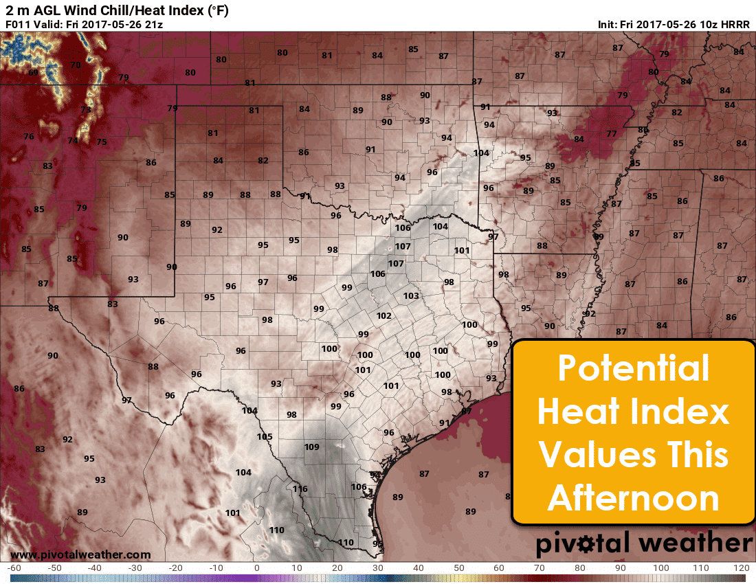
The ‘nasty’ part of this heat will come in the form of the humidity. We’re anticipating heat index values to approach 110 degrees this afternoon in parts of South and Deep South Texas. That is where the juxtaposition of high moisture levels (dewpoint/humidity) plus temperatures in the 90s/100s will exsist. We also note another patch of moisture pooling will allow heat index values to approach 105 degrees across North Texas this afternoon. This being the first real patch of big heat this year I encourage y’all to remain hydrated. Summer heat isn’t atypical in Texas, but heat illnesses can often be exacerbated during the ‘transition’ from cooler temperatures. Take the time to ensure your elderly or susceptible neighbors have a way to stay cool.
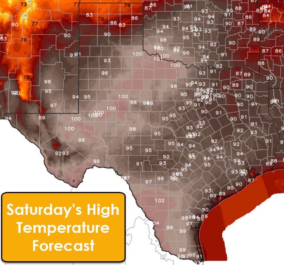
Temperatures on Saturday will once again be warm with high temperatures ranging from the upper 80s in Northeast Texas up into the lower 100s in Northwest Texas southwest through the Permian Basin into South Texas. We do note those lower high temperatures in the northern Panhandle as a cool front starts to progress south. That front will progress south on Saturday and Sunday across Texas. Conditions north of the front will be comparatively cooler with high temperatures dropping back into the 70s and 80s by Monday across most of Texas. We should at least keep highs in the 80s and 90s into the middle of next week behind that front.
Now that we’ve talked about the heat lets dive into thunderstorm chances. Let me start off by saying a vast majority of folks aren’t going to see any precipitation today; and that will likely apply for much of the day Saturday as well. The small percentage who do have to deal with storms this afternoon and Saturday afternoon could be dealing with stronger storms.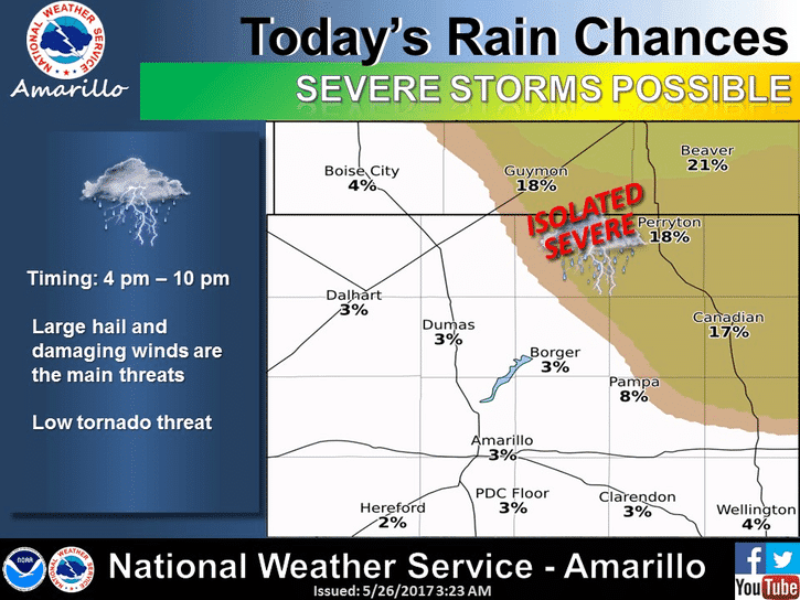
The focus for isolated storm chances today will be in the northeastern Texas Panhandle. A strong cap will be in place today across much of Texas. That cap will prevent thunderstorm development across most of the state today. Upper-level lift will be increasing from Colorado southeast into the eastern Panhandle by this afternoon. That lift may weaken the cap just enough to allow for one or two thunderstorms in the northeastern Panhandle after 4 PM. Should a storm be able to develop it would likely be severe with a threat of large hail and localized damaging wind. A brief tornado can’t be ruled out. All of those threats are conditional on a storm being able to break through the cap and that is far from a guarantee. Assuming a storm can break the cap it would likely be dissipating by 10 PM. Tonight will be quiet across the state as oppressive humidity continues across the eastern half of the state.
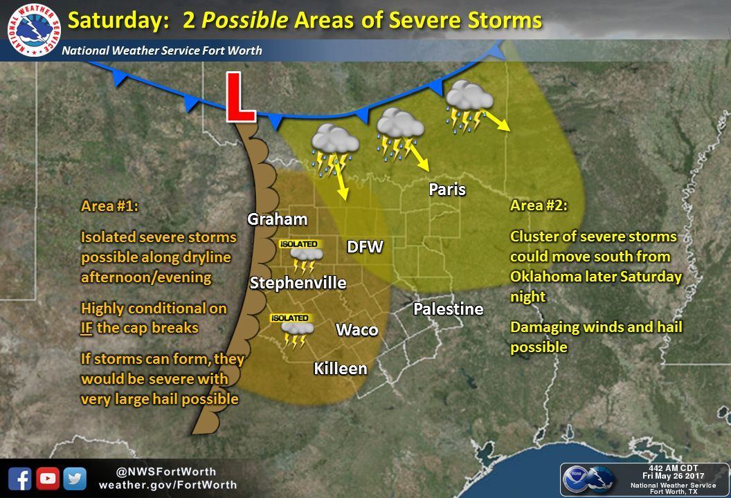
Saturday will bring another conditional chance for thunderstorms across portions of the eastern Big Country, North Texas, and Northeast Texas. By late Saturday afternoon a dryline will be in place across western North Texas with a cold front extending from the Texas Panhandle east/northeast into Northern Oklahoma. A strong cap will be in place and that may prevent any thunderstorms from developing most of the day. If a storm can fire up off the dryline by late Saturday afternoon it would likely become severe with a threat of very large hail, localized damaging wind gusts, and an isolated tornado. However, current data suggests the cap will be quite strong, so it will be a ‘waiting game’ to see if we can even break through the cap. The second possibility of storms will be Saturday night as the cold front pushes south through Oklahoma. A complex of thunderstorms should be underway at that point in eastern Oklahoma. Two solutions are possible with the cold front storms. The first is the storms tend to move more easterly and move into Missouri and Arkansas. The second is that they move more south/southerly and impact parts of Texoma and Northeast Texas. Again, this is another case where we can’t say for sure right now which solution will win out. Regardless of where that complex of storms moves it will likely be severe with damaging winds and the potential for hail. It goes without saying; but be sure to check back tomorrow for the latest forecast. There will likely be changes between now and tomorrow morning.
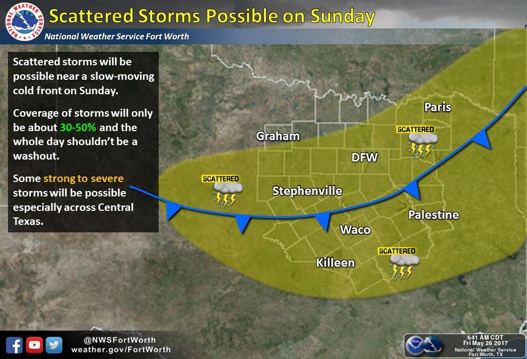
By Sunday the cold front will be slowly moving south from the Big Country into Central Texas into East Texas. This slow-moving front will tend to be a focal point for scattered thunderstorm development throughout the day. Some of the storms may be strong to severe with a threat for hail and damaging wind gusts. We’ll be able to give you a better idea on timing and the area for best rain chances once we get into Saturday.


0 Comments