
Key Messages:
1. Harvey is likely to bring multiple hazards, including prolific rainfall, storm surge, isolated tornadoes, and possible hurricane conditions to portions of the Texas coast beginning on Friday.
2. Heavy to prolific rainfall is likely to spread across portions of eastern Texas, Louisiana, and the lower Mississippi Valley from Friday through early next week and could cause widespread and life-threatening flooding.
3. A Storm Surge Watch is in effect from Port Mansfield to High Island, Texas, indicating the possibility of life-threatening inundation from rising water moving inland from the coast during the next 48 hours. For a depiction of areas at risk, see the Storm Surge Watch/Warning Graphic below.
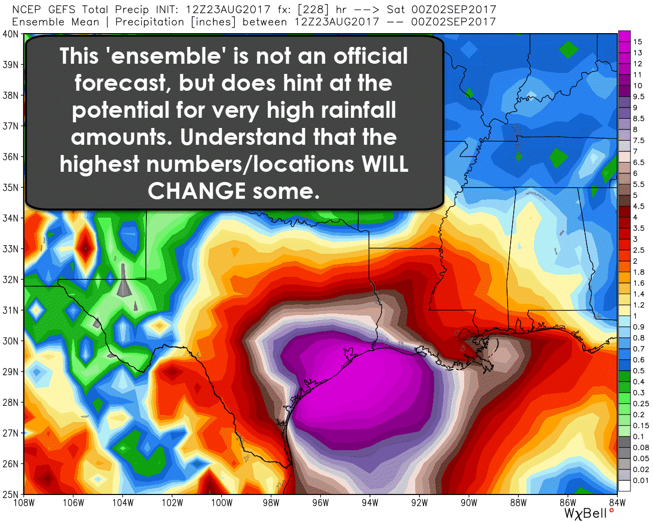
4. There will still be changes to the forecast, but confidence continues to increase that Harvey will cause severe impacts to parts of Texas. Based on the forecast showing Harvey ‘stalling out’ over the state this weekend there is the possibility of catastrophic flooding with rain totals of 10 to 20+ inches.
Situation Overview
Harvey has shown signs of becoming better organized this afternoon. A hurricane hunter aircraft is en route to the system, and it is entirely plausible that it will be upgraded to a tropical storm this evening. Once Harvey is able to develop an organized inner-core the atmospheric conditions will be favorable for intensification. Harvey is expected to be strengthening up until landfall on Friday or Friday Night – and it will likely be a hurricane at landfall somewhere along the Middle Texas or South Texas cost. Locations north/northeast of the landfall location will have a storm surge event – possibly up to 100-150 miles away from landfall. The exact landfall location will change as new data arrives and we get closer in on Friday. Please see the coastal watches/warnings below. After Harvey moves inland it will likely stall out for the weekend. The highest rain totals are likely to be near the center of Harvey and points east. Widespread rain totals of 5 to 20 inches are expected – and localized higher amounts of 25 to 30 inches can’t be ruled out if Harvey does, in fact, stall in the Middle Coast, Coastal Plains, and Southeast Texas through early next week. Those ridiculous rainfall totals would cause widespread, life-threatening flooding. We’ll be doing a live video update on our Facebook page at 4:15 PM CT – after which time we’ll embed it here. Expect our next blog update to be just after the 10 PM advisory from the National Hurricane Center is issued this evening.

Over the next few days you will see this image quite a bit. Be sure to take some time to make sure you know what it means! #txwx #stxwx pic.twitter.com/3d0Q13NMNI
— NWS Corpus Christi (@NWSCorpus) August 23, 2017
4 PM Advisory from the National Hurricane Center
Tropical Depression Harvey Advisory Number 13
NWS National Hurricane Center Miami FL AL092017
400 PM CDT Wed Aug 23 2017
…HARVEY EXPECTED TO STRENGTHEN AS IT HEADS FOR THE TEXAS COAST…
SUMMARY OF 400 PM CDT…2100 UTC…INFORMATION
———————————————-
LOCATION…21.6N 92.6W
ABOUT 525 MI…845 KM SSE OF PORT OCONNOR TEXAS
ABOUT 460 MI…740 KM SE OF PORT MANSFIELD TEXAS
MAXIMUM SUSTAINED WINDS…35 MPH…55 KM/H
PRESENT MOVEMENT…NW OR 320 DEGREES AT 2 MPH…4 KM/H
MINIMUM CENTRAL PRESSURE…1005 MB…29.68 INCHES
WATCHES AND WARNINGS
——————–
CHANGES WITH THIS ADVISORY:
None.
SUMMARY OF WATCHES AND WARNINGS IN EFFECT:
A Storm Surge Watch is in effect for…
* Port Mansfield to High Island
A Hurricane Watch is in effect for…
* North of Port Mansfield to San Luis Pass
A Tropical Storm Watch is in effect for…
* Boca De Catan Mexico to Port Mansfield Texas
* North of San Luis Pass to High Island
A Storm Surge Watch means there is a possibility of life-
threatening inundation, from rising water moving inland from the
coastline, in the indicated locations during the next 48 hours.
For a depiction of areas at risk, please see the National Weather
Service Storm Surge Watch/Warning Graphic, available at
hurricanes.gov.
A Hurricane Watch means that hurricane conditions are possible
within the watch area. A watch is typically issued 48 hours
before the anticipated first occurrence of tropical-storm-force
winds, conditions that make outside preparations difficult or
dangerous.
A Tropical Storm Watch means that tropical storm conditions are
possible within the watch area, generally within 48 hours.
Interests in southwestern Louisiana should continue to monitor the
progress of this system.
For storm information specific to your area in the United States,
including possible inland watches and warnings, please monitor
products issued by your local National Weather Service forecast
office. For storm information specific to your area outside the
United States, please monitor products issued by your national
meteorological service.
DISCUSSION AND 48-HOUR OUTLOOK
——————————
At 400 PM CDT (2100 UTC), the center of Tropical Depression Harvey
was located near latitude 21.6 North, longitude 92.6 West. The
depression is moving toward the northwest near 2 mph (4 km/h).
A track toward the northwest or north-northwest at a faster forward
speed is expected for the next 48 hours. On the forecast track,
Harvey should be approaching the Texas coast late Friday.
Maximum sustained winds are near 35 mph (55 km/h) with higher
gusts. Some strengthening is forecast during the next 48 hours, and
Harvey could become a hurricane on Friday.
The estimated minimum central pressure is 1005 mb (29.68 inches).
HAZARDS AFFECTING LAND
———————-
RAINFALL: Harvey is expected to produce total rain accumulations of
10 to 15 inches with isolated maximum amounts of 20 inches over the
middle and upper Texas coast and southwest Louisiana through next
Tuesday, with heavy rainfall beginning as early as Friday morning.
Harvey is also expected to produce total rain accumulations of 3 to
9 inches in portions of south, central, and northeast Texas and the
rest of the lower Mississippi Valley. Rainfall from Harvey could
cause life-threatening flooding.

STORM SURGE: The combination of a dangerous storm surge and the
tide will cause normally dry areas near the coast to be flooded by
rising waters moving inland from the shoreline. The water is
expected to reach the following heights above ground if the peak
surge occurs at the time of high tide…
Port Mansfield to High Island…4 to 6 ft
The deepest water will occur along the immediate coast near and to
the northeast of the landfall location, where the surge will be
accompanied by large and destructive waves. Surge-related flooding
depends on the relative timing of the surge and the tidal cycle, and
can vary greatly over short distances. For information specific to
your area, please see products issued by your local National Weather
Service forecast office.
WIND: Hurricane conditions are possible within the hurricane watch
area by late Friday, with tropical storm conditions possible by
early Friday.
SURF: Swells generated by Harvey are likely to affect the Texas,
Louisiana, and northeast Mexico coasts by Friday. These swells are
likely to cause life-threatening surf and rip current conditions.
Please consult products from your local weather office.
NEXT ADVISORY
————-
Next intermediate advisory at 700 PM CDT.
Next complete advisory at 1000 PM CDT.


0 Comments