
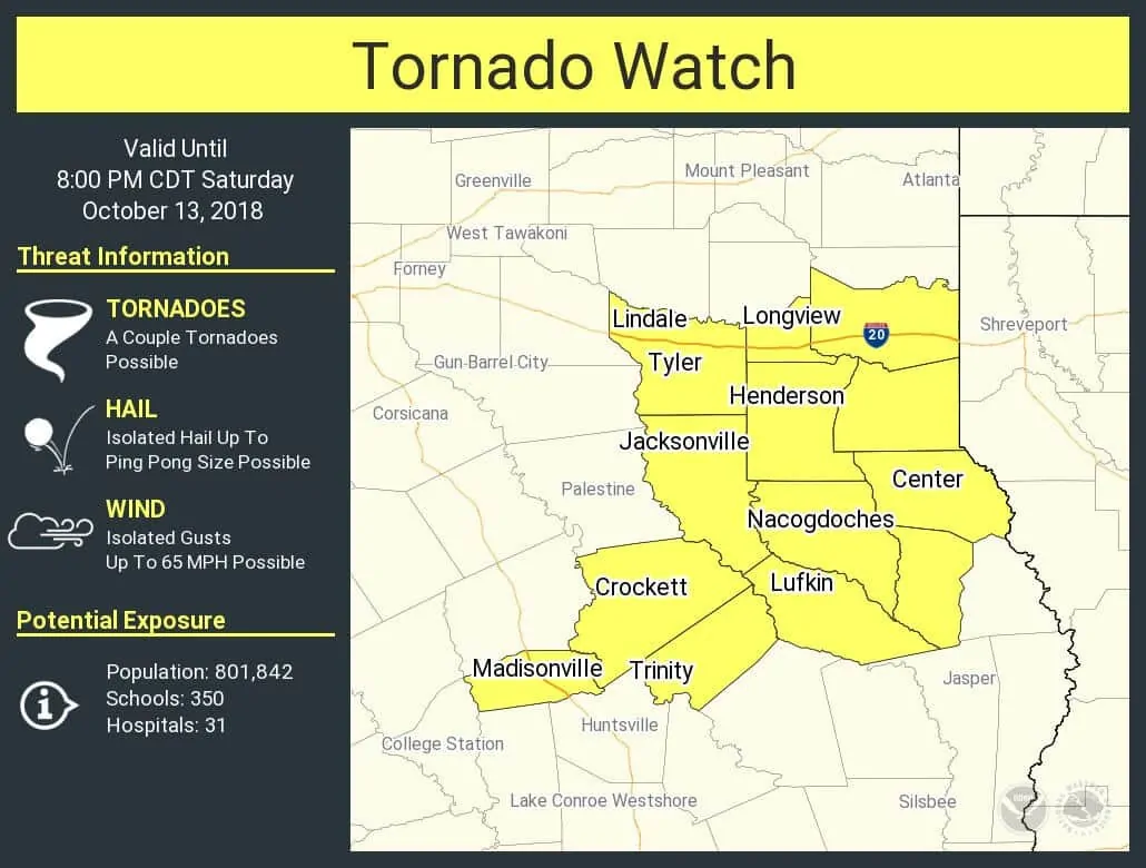
As expected, a new tornado watch has been issued to cover East Texas. This watch runs along and south of Interstate 20 from Tyler to Marshall, south to Madisonville, Trinity, Lufkin, to Hemphill. Strong to severe storms are moving into the watch area from the west. The strongest storms may produce isolated tornadoes, large hail, localized damaging wind gusts, and flooding. Have a way to receive weather warnings and remember, you can always use our free interactive HD weather radar here on our website.
TORNADO WATCH NUMBER 414
NWS STORM PREDICTION CENTER NORMAN OK
305 PM CDT SAT OCT 13 2018

THE NWS STORM PREDICTION CENTER HAS ISSUED A

* TORNADO WATCH FOR PORTIONS OF
  EASTERN TEXAS

* EFFECTIVE THIS SATURDAY AFTERNOON AND EVENING FROM 305 PM UNTIL
  800 PM CDT.

* PRIMARY THREATS INCLUDE...
  A COUPLE TORNADOES POSSIBLE
  ISOLATED DAMAGING WIND GUSTS TO 65 MPH POSSIBLE
  ISOLATED LARGE HAIL EVENTS TO 1.5 INCHES IN DIAMETER POSSIBLE

SUMMARY...A COUPLE OF LONGER-LIVED SUPERCELLS MAY CONTINUE EAST
ACROSS PARTS OF EAST-CENTRAL TEXAS THROUGH EARLY EVENING. ALL
HAZARDS ARE POSSIBLE BEFORE THE TORNADO RISK DIMINISHES LATER THIS
EVENING.

THE TORNADO WATCH AREA IS APPROXIMATELY ALONG AND 50 STATUTE MILES
EAST AND WEST OF A LINE FROM 30 MILES WEST SOUTHWEST OF LUFKIN TX TO
15 MILES NORTH NORTHWEST OF LONGVIEW TX. FOR A COMPLETE DEPICTION OF
THE WATCH SEE THE ASSOCIATED WATCH OUTLINE UPDATE (WOUS64 KWNS
WOU4).


0 Comments